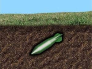
In Ukraine alone, Russians have launched 10-18 million grenades in the current conflict (26-50.000 daily x 1 year), with roughly 60% of them being unexploded ordinance (UXO). They have also scattered an unknown number of anti-tank mines, covering 50% of the country’s area (300,000 km2). Removal estimates stand at 5 years, as the exact locations of both UXO and mines are unknown.
To aid in this process, the Danish government will donate 19 bomb disposal robots, similar to Rulle-Marie, to Ukraine. While these robots excel at eliminating specific threats, they may have limitations in larger areas like fields, forests, and beaches due to their restricted operational range, limited numbers, manpower requirements, and cost-efficiency. Robotic technology could significantly enhance this effort, potentially saving lives.
When it comes to clearing mines and UXO, whether for humanitarian reasons or defense, a critical aspect is rapidly securing as much area as possible. This involves creating a risk map that identifies potential hazards, analyses their severity, and subsequently eliminates them. To automate this process, we propose the following three key steps:
1) UAV based inspection of a designated area using relevant sensors – e.g. IR, multispectral, etc. This is to perform an overall area risk assessment and construct a risk-topographical map.
2) Ground-based coverage of the risk-topographical map using mobile robots equipped with relevant sensors – e.g. ground penetrating radar, “robo sniffers”, hyperspectral imaging, etc. This is to localise, analyse, identify and mark buried UXO – or deem objects “safe.”
3) Removal of threats using mobile robot equipped with digging equipment – e.g. excavators.
The solution involves a collaborative system of UAVs, mobile robots, sensors, and tools, all guided by a dynamic level of human involvement tailored to the robot’s current engagement. Through iterative design, development, and demonstration of system components, we achieve gradual increases in autonomy (reduced human intervention) and the ability to secure larger and diverse terrain. This iterative approach also aims for swift initial results (proof-of-concept and proof-of-technology) that can be deployed in real-life scenarios, while continuously refining and enhancing the technology.